Petoskey night lights from space
Night Light of Petoskey (Michigan) from space (United States) Src. Average luminocity for 10x10km area is 14.7429% and for 50x50km: 1.4792%.
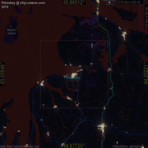
Analysis of Petoskey night lights 2016
Square area 10x10 km:
 0%
0%90-99
0.95%80-89
3.97%70-79
2.22%60-69
3.49%50-59
1.11%40-49
1.75%30-39
1.59%20-29
3.65%10-19
2.38%0-9
78.89%Square area 50x50 km:
0.03%90-99
0.11%80-89
0.3%70-79
0.17%60-69
0.27%50-59
0.22%40-49
0.31%30-39
0.33%20-29
0.44%10-19
0.15%0-9
97.66%Clear (daylight) street map image can be seen on geolist.org.
Map coordinates:
45° 51' 54.4" North, 85° 39' 30.5" West
45° 22' 24" North, 84° 57' 19.2" West
44° 52' 38.1" North, 84° 15' 8" West
Some cities around Petoskey sort by population:
• Sault Ste. Marie, CA
135.9 km =84.4 mi,  20°
20°
• Traverse City
85.6 km =53.2 mi,  217°
217°
• Sault Ste. Marie
133.4 km =82.9 mi, 20°
• Escanaba
169.3 km =105.2 mi,  284°
284°
• Cadillac
129.6 km =80.5 mi,  195°
195°
• Alpena
124.2 km =77.2 mi,  106°
106°
• Manistee
165.6 km =102.9 mi, 220°
• Bay Harbor
10 km =6.2 mi,  264°
264°
5005484 (p: 5,719)
Sources (retrieved 2019-11-25):
» Earth at Night: Flat Maps 2012, 2016