Parsons night lights from space
Night Light of Parsons (Kansas) from space (United States) Src. Average luminocity for 10x10km area is 21.1705% and for 50x50km: 1.4156%.
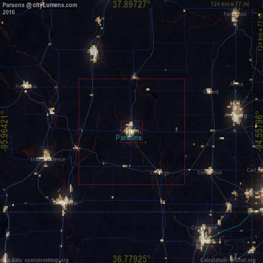
Analysis of Parsons night lights 2016
Square area 10x10 km:
 1.95%
1.95%90-99
2.6%80-89
3.25%70-79
2.92%60-69
2.76%50-59
5.84%40-49
2.76%30-39
1.46%20-29
2.11%10-19
13.47%0-9
60.88%Square area 50x50 km:
0.1%90-99
0.12%80-89
0.26%70-79
0.22%60-69
0.15%50-59
0.38%40-49
0.18%30-39
0.17%20-29
0.19%10-19
0.66%0-9
97.58%Clear (daylight) street map image can be seen on geolist.org.
Map coordinates:
37° 53' 50.2" North, 95° 57' 51.2" West
37° 20' 25.2" North, 95° 15' 39.9" West
36° 46' 45.3" North, 94° 33' 28.7" West
Some cities around Parsons sort by population:
• Joplin
72.1 km =44.8 mi,  113°
113°
• Pittsburg
49.8 km =30.9 mi,  80°
80°
• Miami
62 km =38.5 mi,  146°
146°
• Coffeyville
46.1 km =28.6 mi,  223°
223°
• Chanute
41.5 km =25.8 mi,  335°
335°
• Independence
41.6 km =25.8 mi,  251°
251°
• Carl Junction
64.2 km =39.9 mi, 106°
• Iola
66.1 km =41.1 mi,  349°
349°
4277011 (p: 10,090)
Sources (retrieved 2019-11-25):
» Earth at Night: Flat Maps 2012, 2016