Coffeyville night lights from space
Night Light of Coffeyville (Kansas) from space (United States) Src. Average luminocity for 10x10km area is 31.4354% and for 50x50km: 2.7092%.
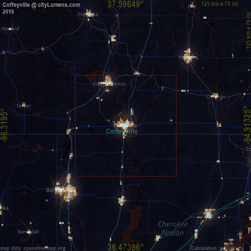
Analysis of Coffeyville night lights 2016
Square area 10x10 km:
 4.08%
4.08%90-99
5.1%80-89
4.42%70-79
3.91%60-69
4.59%50-59
4.93%40-49
3.4%30-39
2.55%20-29
3.74%10-19
40.31%0-9
22.96%Square area 50x50 km:
0.24%90-99
0.32%80-89
0.47%70-79
0.31%60-69
0.39%50-59
0.42%40-49
0.2%30-39
0.52%20-29
0.27%10-19
2.52%0-9
94.34%Clear (daylight) street map image can be seen on geolist.org.
Map coordinates:
37° 35' 47.4" North, 96° 19' 10.2" West
37° 2' 14.3" North, 95° 36' 58.9" West
36° 28' 26.3" North, 94° 54' 47.7" West
Some cities around Coffeyville sort by population:
• Bartlesville
45.7 km =28.4 mi,  225°
225°
• Claremore
80.6 km =50.1 mi,  179°
179°
• Miami
68.1 km =42.3 mi,  105°
105°
• Parsons
46.1 km =28.6 mi,  43°
43°
• Chanute
72.7 km =45.2 mi,  11°
11°
• Independence
22.3 km =13.9 mi,  338°
338°
• Collinsville
77.4 km =48.1 mi,  194°
194°
• Vinita
60.5 km =37.6 mi,  137°
137°
4269789 (p: 9,669)
Sources (retrieved 2019-11-25):
» Earth at Night: Flat Maps 2012, 2016