Paradise Valley night lights from space
Night Light of Paradise Valley (Arizona) from space (United States) Src. Average luminocity for 10x10km area is 85.4176% and for 50x50km: 73.1545%.
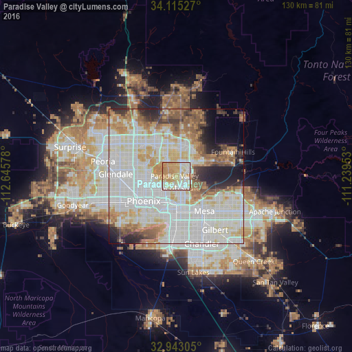
Analysis of Paradise Valley night lights 2016
Square area 10x10 km:
 17.95%
90-99
24.73%80-89
17.77%70-79
30.4%60-69
9.16%50-59
0%40-49
0%30-39
0%20-29
0%10-19
0%0-9
0%Square area 50x50 km:
25.99%90-99
22.01%80-89
8.45%70-79
8.03%60-69
7.43%50-59
6.23%40-49
2.8%30-39
3.35%20-29
4.56%10-19
5.58%0-9
5.58%Clear (daylight) street map image can be seen on geolist.org.
Map coordinates:
34° 6' 55" North, 112° 38' 44.8" West
33° 31' 52.1" North, 111° 56' 33.5" West
32° 56' 35" North, 111° 14' 22.3" West
Some cities around Paradise Valley sort by population:
• Phoenix
15.3 km =9.5 mi,  232°
232°
• Mesa
16.4 km =10.2 mi,  137°
137°
• Scottsdale
4.7 km =2.9 mi,  121°
121°
• Tempe
13.3 km =8.3 mi,  166°
166°
• Tempe Junction
13 km =8.1 mi,  180°
180°
• Central City
14.7 km =9.1 mi, 226°
• Encanto
13.8 km =8.6 mi,  245°
245°
• Guadalupe
17.9 km =11.1 mi,  186°
186°
5308049 (p: 13,922)
Sources (retrieved 2019-11-25):
» Earth at Night: Flat Maps 2012, 2016