Murphy night lights from space
Night Light of Murphy (Missouri) from space (United States) Src. Average luminocity for 10x10km area is 60.1039% and for 50x50km: 45.1235%.
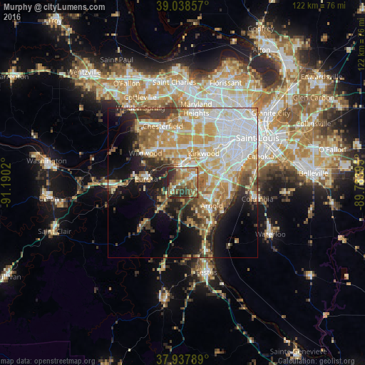
Analysis of Murphy night lights 2016
Square area 10x10 km:
 5.36%
5.36%90-99
8.6%80-89
6.49%70-79
10.71%60-69
19.81%50-59
14.61%40-49
11.69%30-39
12.18%20-29
10.55%10-19
0%0-9
0%Square area 50x50 km:
11.63%90-99
8.27%80-89
6.05%70-79
8.57%60-69
6.27%50-59
5.37%40-49
3.64%30-39
4.84%20-29
5.99%10-19
10.53%0-9
28.84%Clear (daylight) street map image can be seen on geolist.org.
Map coordinates:
39° 2' 18.9" North, 91° 11' 24.7" West
38° 29' 25.2" North, 90° 29' 13.5" West
37° 56' 16.4" North, 89° 47' 2.2" West
Some cities around Murphy sort by population:
• Arnold
11.5 km =7.1 mi,  123°
123°
• Manchester
12 km =7.5 mi,  350°
350°
• Concord
11.9 km =7.4 mi,  71°
71°
• Crestwood
11.8 km =7.3 mi,  51°
51°
• Eureka
12.3 km =7.6 mi,  276°
276°
• Sunset Hills
8.8 km =5.5 mi, 52°
• Sappington
10.7 km =6.6 mi,  60°
60°
• Valley Park
6.6 km =4.1 mi,  355°
355°
4399914 (p: 8,690)
Sources (retrieved 2019-11-25):
» Earth at Night: Flat Maps 2012, 2016