Orrville night lights from space
Night Light of Orrville (Ohio) from space (United States) Src. Average luminocity for 10x10km area is 25.3384% and for 50x50km: 22.1515%.
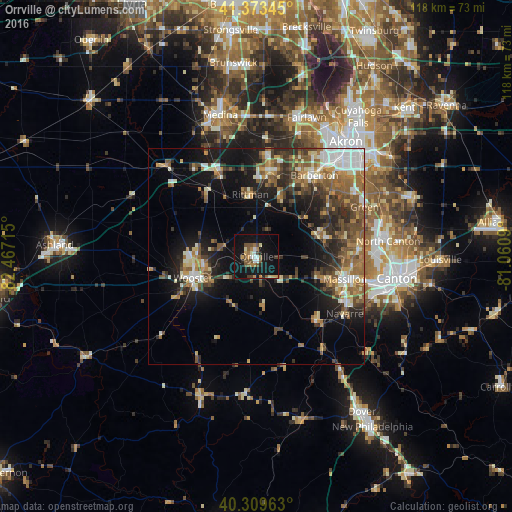
Analysis of Orrville night lights 2016
Square area 10x10 km:
 2.21%
2.21%90-99
3.74%80-89
1.87%70-79
2.89%60-69
3.91%50-59
4.93%40-49
5.61%30-39
1.36%20-29
2.38%10-19
39.8%0-9
31.29%Square area 50x50 km:
2.51%90-99
3.6%80-89
2.15%70-79
2.51%60-69
3.91%50-59
4.05%40-49
4.09%30-39
3.91%20-29
5.83%10-19
12.55%0-9
54.9%Clear (daylight) street map image can be seen on geolist.org.
Map coordinates:
41° 22' 24.4" North, 82° 28' 1.7" West
40° 50' 37.2" North, 81° 45' 50.5" West
40° 18' 34.7" North, 81° 3' 39.2" West
Some cities around Orrville sort by population:
• Massillon
21.1 km =13.1 mi,  104°
104°
• Wooster
15.1 km =9.4 mi,  253°
253°
• Barberton
23.1 km =14.4 mi,  35°
35°
• Wadsworth
20.4 km =12.7 mi,  8°
8°
• New Franklin
21.6 km =13.4 mi,  59°
59°
• Norton
23.2 km =14.4 mi,  27°
27°
• Rittman
15 km =9.3 mi,  354°
354°
• Canal Fulton
14.9 km =9.3 mi,  69°
69°
5165755 (p: 8,491)
Sources (retrieved 2019-11-25):
» Earth at Night: Flat Maps 2012, 2016