Wadsworth night lights from space
Night Light of Wadsworth (Ohio) from space (United States) Src. Average luminocity for 10x10km area is 44.7755% and for 50x50km: 36.8198%.

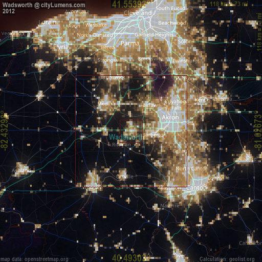
Analysis of Wadsworth night lights 2016
Square area 10x10 km:
 4.42%
4.42%90-99
6.97%80-89
3.4%70-79
5.95%60-69
7.14%50-59
10.88%40-49
6.97%30-39
13.61%20-29
21.6%10-19
19.05%0-9
0%Square area 50x50 km:
5.42%90-99
6.56%80-89
2.98%70-79
4.08%60-69
7.58%50-59
7.29%40-49
6.11%30-39
6.19%20-29
10.5%10-19
16.21%0-9
27.08%Clear (daylight) street map image can be seen on geolist.org.
Map coordinates:
41° 33' 14.1" North, 82° 25' 58.7" West
41° 1' 32.2" North, 81° 43' 47.5" West
40° 29' 34.9" North, 81° 1' 36.2" West
Some cities around Wadsworth sort by population:
• Medina
16.8 km =10.4 mi,  318°
318°
• Barberton
10.6 km =6.6 mi,  97°
97°
• Copley
10.8 km =6.7 mi,  41°
41°
• Norton
7.7 km =4.8 mi,  87°
87°
• Fairlawn
15.2 km =9.4 mi, 41°
• Portage Lakes
17.1 km =10.6 mi, 96°
• Rittman
6.9 km =4.3 mi,  219°
219°
• Montrose-Ghent
16 km =9.9 mi,  26°
26°
5175496 (p: 21,860)
Sources (retrieved 2019-11-25):
» Earth at Night: Flat Maps 2012, 2016