Rittman night lights from space
Night Light of Rittman (Ohio) from space (United States) Src. Average luminocity for 10x10km area is 23.1276% and for 50x50km: 30.2253%.
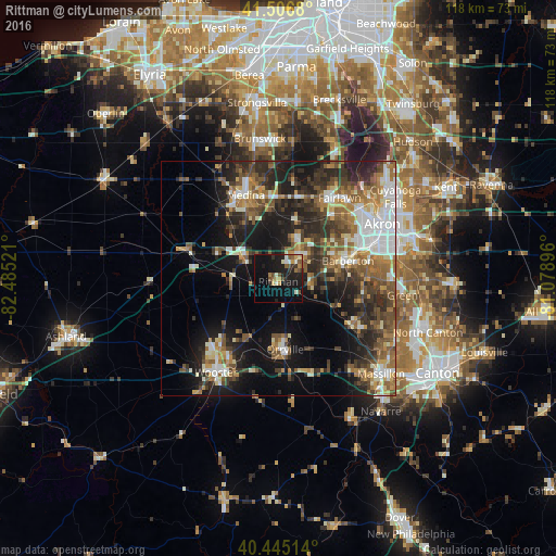
Analysis of Rittman night lights 2016
Square area 10x10 km:
 1.02%
1.02%90-99
4.42%80-89
2.21%70-79
2.55%60-69
2.04%50-59
3.91%40-49
4.25%30-39
2.21%20-29
7.48%10-19
28.57%0-9
41.33%Square area 50x50 km:
4.22%90-99
5.23%80-89
2.62%70-79
3.23%60-69
5.22%50-59
5.28%40-49
5.49%30-39
5.73%20-29
9.65%10-19
15.19%0-9
38.14%Clear (daylight) street map image can be seen on geolist.org.
Map coordinates:
41° 30' 24.5" North, 82° 29' 6.8" West
40° 58' 41.2" North, 81° 46' 55.5" West
40° 26' 42.5" North, 81° 4' 44.3" West
Some cities around Rittman sort by population:
• Medina
19.1 km =11.9 mi,  338°
338°
• Barberton
15.3 km =9.5 mi,  75°
75°
• Wadsworth
6.9 km =4.3 mi,  39°
39°
• New Franklin
20.6 km =12.8 mi,  101°
101°
• Copley
17.7 km =11 mi, 40°
• Norton
13.3 km =8.3 mi,  64°
64°
• Orrville
15 km =9.3 mi,  174°
174°
• Canal Fulton
18.3 km =11.4 mi,  122°
122°
5168225 (p: 6,580)
Sources (retrieved 2019-11-25):
» Earth at Night: Flat Maps 2012, 2016