Canal Fulton night lights from space
Night Light of Canal Fulton (Ohio) from space (United States) Src. Average luminocity for 10x10km area is 23.4082% and for 50x50km: 37.0083%.
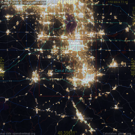
Analysis of Canal Fulton night lights 2016
Square area 10x10 km:
 0.51%
0.51%90-99
2.55%80-89
1.7%70-79
2.38%60-69
2.89%50-59
2.89%40-49
1.87%30-39
10.03%20-29
20.92%10-19
21.94%0-9
32.31%Square area 50x50 km:
5.97%90-99
6.84%80-89
3.32%70-79
4.15%60-69
6.9%50-59
7.48%40-49
6.61%30-39
5.69%20-29
8.29%10-19
13.99%0-9
30.77%Clear (daylight) street map image can be seen on geolist.org.
Map coordinates:
41° 25' 9" North, 82° 18' 2.7" West
40° 53' 23.2" North, 81° 35' 51.4" West
40° 21' 22" North, 80° 53' 40.2" West
Some cities around Canal Fulton sort by population:
• Massillon
12.2 km =7.6 mi,  148°
148°
• Barberton
13.7 km =8.5 mi,  357°
357°
• Green
11.5 km =7.1 mi,  57°
57°
• New Franklin
7.5 km =4.7 mi,  39°
39°
• Norton
15.9 km =9.9 mi,  347°
347°
• Orrville
14.9 km =9.3 mi,  249°
249°
• Perry Heights
14.8 km =9.2 mi,  135°
135°
• Portage Lakes
14.3 km =8.9 mi,  24°
24°
5149188 (p: 5,487)
Sources (retrieved 2019-11-25):
» Earth at Night: Flat Maps 2012, 2016