Orlovista night lights from space
Night Light of Orlovista (Florida) from space (United States) Src. Average luminocity for 10x10km area is 98.3049% and for 50x50km: 74.2652%.
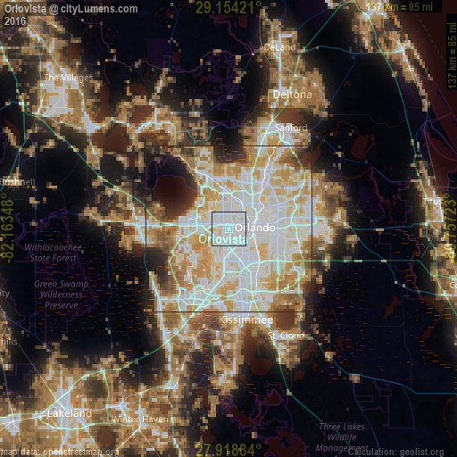
Analysis of Orlovista night lights 2016
Square area 10x10 km:
 50.76%
90-99
44.51%80-89
4.73%70-79
0%60-69
0%50-59
0%40-49
0%30-39
0%20-29
0%10-19
0%0-9
0%Square area 50x50 km:
23.54%90-99
22.52%80-89
9.71%70-79
10.66%60-69
9.41%50-59
3.68%40-49
2.96%30-39
3.29%20-29
5.09%10-19
4.94%0-9
4.19%Clear (daylight) street map image can be seen on geolist.org.
Map coordinates:
29° 9' 15.2" North, 82° 9' 48.5" West
28° 32' 18" North, 81° 27' 37.3" West
27° 55' 7.8" North, 80° 45' 26" West
Some cities around Orlovista sort by population:
• Orlando
7.9 km =4.9 mi,  90°
90°
• Pine Hills
2.3 km =1.4 mi,  17°
17°
• Ocoee
8.9 km =5.5 mi,  292°
292°
• Oak Ridge
8.3 km =5.2 mi,  154°
154°
• Lake Butler
8.9 km =5.5 mi,  242°
242°
• Lockhart
9.2 km =5.7 mi,  10°
10°
• Doctor Phillips
10.4 km =6.5 mi,  197°
197°
• Fairview Shores
8.7 km =5.4 mi,  47°
47°
4167176 (p: 6,123)
Sources (retrieved 2019-11-25):
» Earth at Night: Flat Maps 2012, 2016