Doctor Phillips night lights from space
Night Light of Doctor Phillips (Florida) from space (United States) Src. Average luminocity for 10x10km area is 89.9345% and for 50x50km: 73.1438%.
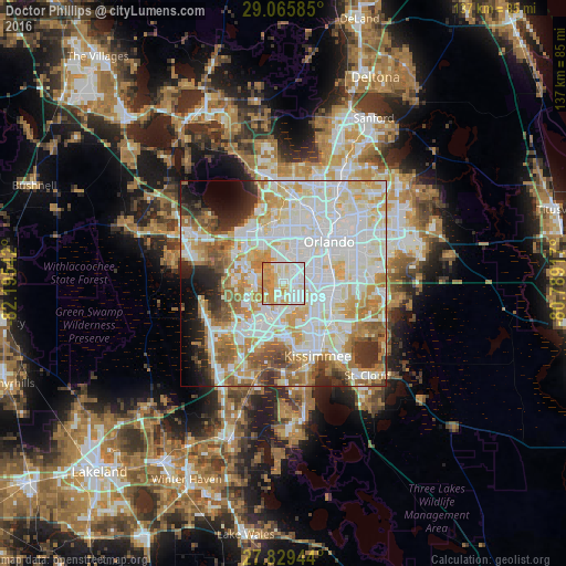
Analysis of Doctor Phillips night lights 2016
Square area 10x10 km:
 32.14%
90-99
25.4%80-89
16.07%70-79
23.81%60-69
2.58%50-59
0%40-49
0%30-39
0%20-29
0%10-19
0%0-9
0%Square area 50x50 km:
23.26%90-99
21.93%80-89
9.17%70-79
9.21%60-69
9.47%50-59
5.37%40-49
3.59%30-39
3.74%20-29
4.78%10-19
4.47%0-9
5.02%Clear (daylight) street map image can be seen on geolist.org.
Map coordinates:
29° 3' 57.1" North, 82° 11' 43.5" West
28° 26' 58" North, 81° 29' 32.2" West
27° 49' 46" North, 80° 47' 21" West
Some cities around Doctor Phillips sort by population:
• Oak Ridge
7 km =4.3 mi,  70°
70°
• Southchase
12.4 km =7.7 mi,  120°
120°
• Lake Butler
7.5 km =4.7 mi,  320°
320°
• Hunters Creek
12 km =7.5 mi,  145°
145°
• Pine Castle
12.4 km =7.7 mi,  78°
78°
• Williamsburg
6.2 km =3.9 mi,  128°
128°
• Sky Lake
9.9 km =6.2 mi, 84°
• Orlovista
10.4 km =6.5 mi,  17°
17°
4153367 (p: 10,981)
Sources (retrieved 2019-11-25):
» Earth at Night: Flat Maps 2012, 2016