Odessa night lights from space
Night Light of Odessa (Missouri) from space (United States) Src. Average luminocity for 10x10km area is 8.3036% and for 50x50km: 4.5587%.
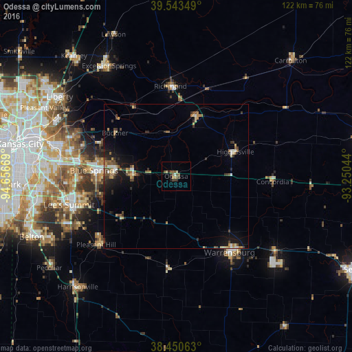
Analysis of Odessa night lights 2016
Square area 10x10 km:
 0.16%
0.16%90-99
0.49%80-89
1.3%70-79
0.16%60-69
1.3%50-59
3.73%40-49
2.11%30-39
2.27%20-29
1.14%10-19
0.32%0-9
87.01%Square area 50x50 km:
0.28%90-99
0.42%80-89
0.5%70-79
0.56%60-69
0.71%50-59
0.82%40-49
0.81%30-39
1.07%20-29
0.85%10-19
3.08%0-9
90.89%Clear (daylight) street map image can be seen on geolist.org.
Map coordinates:
39° 32' 36.6" North, 94° 39' 24.1" West
38° 59' 57" North, 93° 57' 12.8" West
38° 27' 2.3" North, 93° 15' 1.6" West
Some cities around Odessa sort by population:
• East Independence
36.3 km =22.6 mi,  287°
287°
• Blue Springs
28.4 km =17.6 mi,  273°
273°
• Warrensburg
32.3 km =20.1 mi,  144°
144°
• Grain Valley
21.2 km =13.2 mi, 274°
• Pleasant Hill
36.1 km =22.4 mi,  229°
229°
• Oak Grove
15.2 km =9.4 mi, 272°
• Richmond
31.1 km =19.3 mi,  356°
356°
• Greenwood
37.5 km =23.3 mi,  244°
244°
4401659 (p: 5,178)
Sources (retrieved 2019-11-25):
» Earth at Night: Flat Maps 2012, 2016