Warrensburg night lights from space
Night Light of Warrensburg (Missouri) from space (United States) Src. Average luminocity for 10x10km area is 31.5408% and for 50x50km: 3.0726%.
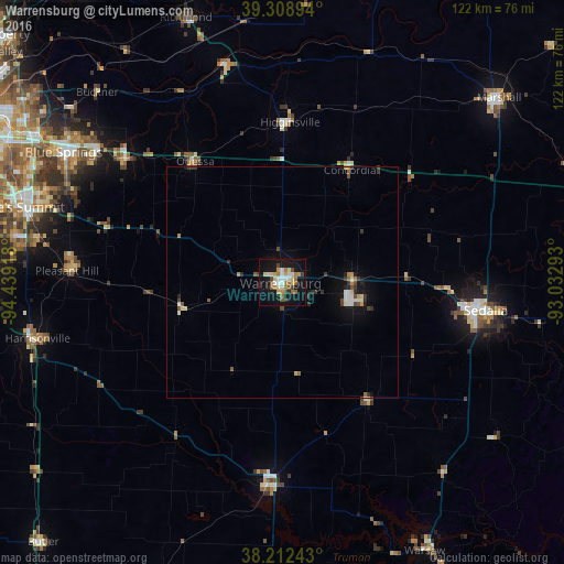

Analysis of Warrensburg night lights 2016
Square area 10x10 km:
 4.25%
4.25%90-99
4.93%80-89
5.78%70-79
3.57%60-69
3.74%50-59
5.78%40-49
3.4%30-39
2.21%20-29
1.36%10-19
38.61%0-9
26.36%Square area 50x50 km:
0.36%90-99
0.42%80-89
0.39%70-79
0.34%60-69
0.24%50-59
0.47%40-49
0.42%30-39
0.49%20-29
0.39%10-19
2.63%0-9
93.85%Clear (daylight) street map image can be seen on geolist.org.
Map coordinates:
39° 18' 32.2" North, 94° 26' 21" West
38° 45' 46" North, 93° 44' 9.8" West
38° 12' 44.7" North, 93° 1' 58.5" West
Some cities around Warrensburg sort by population:
• Sedalia
44.5 km =27.7 mi,  98°
98°
• Grain Valley
48.9 km =30.4 mi,  305°
305°
• Harrisonville
54.5 km =33.9 mi,  257°
257°
• Clinton
44 km =27.3 mi,  184°
184°
• Pleasant Hill
46.3 km =28.8 mi,  273°
273°
• Oak Grove
43.4 km =27 mi, 308°
• Greenwood
53.6 km =33.3 mi,  280°
280°
• Odessa
32.3 km =20.1 mi,  324°
324°
4413595 (p: 19,927)
Sources (retrieved 2019-11-25):
» Earth at Night: Flat Maps 2012, 2016