Oak Grove night lights from space
Night Light of Oak Grove (Missouri) from space (United States) Src. Average luminocity for 10x10km area is 16.914% and for 50x50km: 15.8615%.
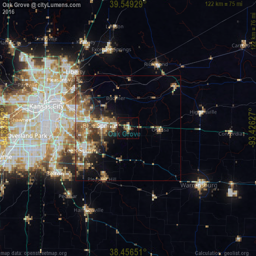
Analysis of Oak Grove night lights 2016
Square area 10x10 km:
 1.14%
1.14%90-99
1.46%80-89
1.14%70-79
1.79%60-69
2.76%50-59
3.73%40-49
2.6%30-39
2.27%20-29
1.95%10-19
24.19%0-9
56.98%Square area 50x50 km:
1.65%90-99
2.06%80-89
1.73%70-79
2.18%60-69
3.35%50-59
3.4%40-49
3.42%30-39
3.54%20-29
3.11%10-19
5.74%0-9
69.81%Clear (daylight) street map image can be seen on geolist.org.
Map coordinates:
39° 32' 57.4" North, 94° 49' 57.1" West
39° 0' 18" North, 94° 7' 45.8" West
38° 27' 23.4" North, 93° 25' 34.6" West
Some cities around Oak Grove sort by population:
• Independence
26.5 km =16.5 mi,  291°
291°
• East Independence
21.9 km =13.6 mi,  297°
297°
• Lee's Summit
24.2 km =15 mi,  244°
244°
• Blue Springs
13.2 km =8.2 mi,  275°
275°
• Grain Valley
6.1 km =3.8 mi, 280°
• Pleasant Hill
27 km =16.8 mi,  206°
206°
• Greenwood
25.2 km =15.7 mi,  227°
227°
• Odessa
15.2 km =9.4 mi,  92°
92°
4401282 (p: 7,937)
Sources (retrieved 2019-11-25):
» Earth at Night: Flat Maps 2012, 2016