Norton night lights from space
Night Light of Norton (Massachusetts) from space (United States) Src. Average luminocity for 10x10km area is 40.6492% and for 50x50km: 47.3423%.
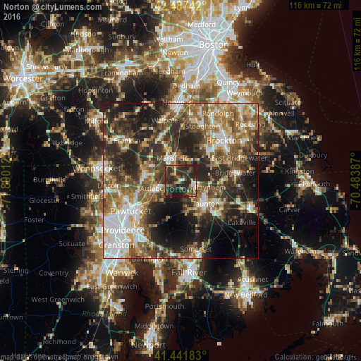
Analysis of Norton night lights 2016
Square area 10x10 km:
 3.02%
3.02%90-99
4.44%80-89
1.59%70-79
4.44%60-69
4.6%50-59
7.94%40-49
10.63%30-39
22.38%20-29
33.33%10-19
7.62%0-9
0%Square area 50x50 km:
7.84%90-99
7.94%80-89
5.25%70-79
5.24%60-69
7.75%50-59
9.73%40-49
9.29%30-39
9.67%20-29
14.55%10-19
12.6%0-9
10.16%Clear (daylight) street map image can be seen on geolist.org.
Map coordinates:
42° 29' 14.7" North, 71° 53' 24.4" West
41° 58' 0.4" North, 71° 11' 13.2" West
41° 26' 30.6" North, 70° 29' 1.9" West
Some cities around Norton sort by population:
• Taunton
10.9 km =6.8 mi,  132°
132°
• Attleboro
8.5 km =5.3 mi,  253°
253°
• Easton
8 km =5 mi,  36°
36°
• Mansfield
7.9 km =4.9 mi,  340°
340°
• North Attleborough Center
11.4 km =7.1 mi,  273°
273°
• Raynham
9.6 km =6 mi,  102°
102°
• Mansfield Center
6.7 km =4.2 mi, 337°
• Foxborough
12.1 km =7.5 mi, 335°
4945911 (p: 19,808)
Sources (retrieved 2019-11-25):
» Earth at Night: Flat Maps 2012, 2016