Raynham night lights from space
Night Light of Raynham (Massachusetts) from space (United States) Src. Average luminocity for 10x10km area is 51.873% and for 50x50km: 37.5228%.
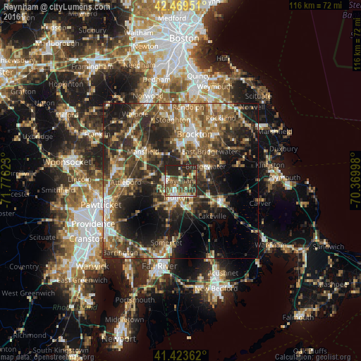
Analysis of Raynham night lights 2016
Square area 10x10 km:
 5.71%
5.71%90-99
7.46%80-89
7.78%70-79
5.24%60-69
4.6%50-59
17.14%40-49
12.38%30-39
12.22%20-29
27.3%10-19
0.16%0-9
0%Square area 50x50 km:
3.87%90-99
5.44%80-89
4.15%70-79
4.06%60-69
6.44%50-59
8.72%40-49
8.68%30-39
8.88%20-29
13.58%10-19
14.02%0-9
22.14%Clear (daylight) street map image can be seen on geolist.org.
Map coordinates:
42° 28' 10.2" North, 71° 46' 34.4" West
41° 56' 55.4" North, 71° 4' 23.2" West
41° 25' 25" North, 70° 22' 11.9" West
Some cities around Raynham sort by population:
• Taunton
5.6 km =3.5 mi,  194°
194°
• Easton
9.6 km =6 mi,  331°
331°
• Norton
9.6 km =6 mi,  282°
282°
• East Bridgewater
13.3 km =8.3 mi,  44°
44°
• Bridgewater
9.3 km =5.8 mi,  60°
60°
• Middleborough Center
13.6 km =8.5 mi,  116°
116°
• West Bridgewater
9.5 km =5.9 mi,  34°
34°
• Berkley
11.5 km =7.1 mi,  184°
184°
4948449 (p: 13,153)
Sources (retrieved 2019-11-25):
» Earth at Night: Flat Maps 2012, 2016