Wescosville night lights from space
Night Light of Wescosville (Pennsylvania) from space (United States) Src. Average luminocity for 10x10km area is 79.9838% and for 50x50km: 27.7556%.
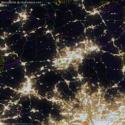
Analysis of Wescosville night lights 2016
Square area 10x10 km:
 18.67%
90-99
19.97%80-89
11.04%70-79
13.96%60-69
24.19%50-59
11.36%40-49
0.81%30-39
0%20-29
0%10-19
0%0-9
0%Square area 50x50 km:
4.02%90-99
4.24%80-89
3.18%70-79
3.51%60-69
5.14%50-59
4.54%40-49
4%30-39
4.9%20-29
6.42%10-19
15.34%0-9
44.7%Clear (daylight) street map image can be seen on geolist.org.
Map coordinates:
41° 5' 55.5" North, 76° 15' 21.9" West
40° 34' 0.3" North, 75° 33' 10.7" West
40° 1' 49.8" North, 74° 50' 59.4" West
Some cities around Wescosville sort by population:
• Allentown
7 km =4.3 mi,  48°
48°
• Whitehall Township
12 km =7.5 mi,  21°
21°
• Fullerton
9.9 km =6.2 mi,  42°
42°
• Emmaus
5.6 km =3.5 mi,  122°
122°
• Northampton
14.1 km =8.8 mi, 19°
• Ancient Oaks
3.8 km =2.4 mi,  234°
234°
• Catasauqua
11.8 km =7.3 mi,  34°
34°
• Red Lion
11 km =6.8 mi,  209°
209°
5218505 (p: 5,872)
Sources (retrieved 2019-11-25):
» Earth at Night: Flat Maps 2012, 2016