Sugarmill Woods night lights from space
Night Light of Sugarmill Woods (Florida) from space (United States) Src. Average luminocity for 10x10km area is 32.0152% and for 50x50km: 18.8128%.
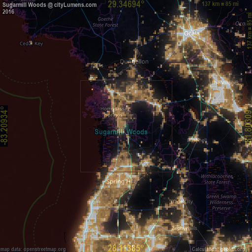
Analysis of Sugarmill Woods night lights 2016
Square area 10x10 km:
 0%
0%90-99
0%80-89
0%70-79
0.95%60-69
17.05%50-59
17.99%40-49
6.06%30-39
4.36%20-29
5.87%10-19
25.57%0-9
22.16%Square area 50x50 km:
0.56%90-99
0.7%80-89
0.56%70-79
1.22%60-69
9.09%50-59
4.7%40-49
4.34%30-39
4.37%20-29
6.31%10-19
12.62%0-9
55.53%Clear (daylight) street map image can be seen on geolist.org.
Map coordinates:
29° 20' 49" North, 83° 12' 33.6" West
28° 43' 56" North, 82° 30' 22.4" West
28° 6' 49.9" North, 81° 48' 11.1" West
Some cities around Sugarmill Woods sort by population:
• Homosassa Springs
10.4 km =6.5 mi,  319°
319°
• North Weeki Wachee
20.9 km =13 mi,  194°
194°
• Beverly Hills
21.1 km =13.1 mi,  12°
12°
• Citrus Hills
18.8 km =11.7 mi,  22°
22°
• Inverness
20.6 km =12.8 mi,  56°
56°
• Inverness Highlands South
18.1 km =11.2 mi,  65°
65°
• Lecanto
13.4 km =8.3 mi, 7°
• Floral City
20.5 km =12.7 mi,  84°
84°
4174252 (p: 8,287)
Sources (retrieved 2019-11-25):
» Earth at Night: Flat Maps 2012, 2016