North Smithfield night lights from space
Night Light of North Smithfield (Rhode Island) from space (United States) Src. Average luminocity for 10x10km area is 39.0921% and for 50x50km: 32.4214%.
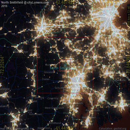
Analysis of North Smithfield night lights 2016
Square area 10x10 km:
 5.24%
5.24%90-99
4.6%80-89
6.67%70-79
3.02%60-69
7.14%50-59
5.08%40-49
6.35%30-39
11.59%20-29
17.78%10-19
17.78%0-9
14.76%Square area 50x50 km:
5.76%90-99
5.06%80-89
3.25%70-79
3.62%60-69
4.76%50-59
5.75%40-49
5.93%30-39
6.71%20-29
10.15%10-19
13.31%0-9
35.69%Clear (daylight) street map image can be seen on geolist.org.
Map coordinates:
42° 29' 14.7" North, 72° 15' 9.5" West
41° 58' 0.4" North, 71° 32' 58.2" West
41° 26' 30.6" North, 70° 50' 47" West
Some cities around North Smithfield sort by population:
• Woonsocket
4.9 km =3 mi,  35°
35°
• Cumberland
9.6 km =6 mi,  90°
90°
• Smithfield
5 km =3.1 mi,  180°
180°
• Lincoln
10.7 km =6.6 mi,  118°
118°
• Uxbridge
14 km =8.7 mi,  331°
331°
• Blackstone
5.7 km =3.5 mi,  6°
6°
• Greenville
10.6 km =6.6 mi, 181°
• Cumberland Hill
6.9 km =4.3 mi,  82°
82°
5223687 (p: 11,212)
Sources (retrieved 2019-11-25):
» Earth at Night: Flat Maps 2012, 2016