Cumberland Hill night lights from space
Night Light of Cumberland Hill (Rhode Island) from space (United States) Src. Average luminocity for 10x10km area is 61.5952% and for 50x50km: 36.3052%.
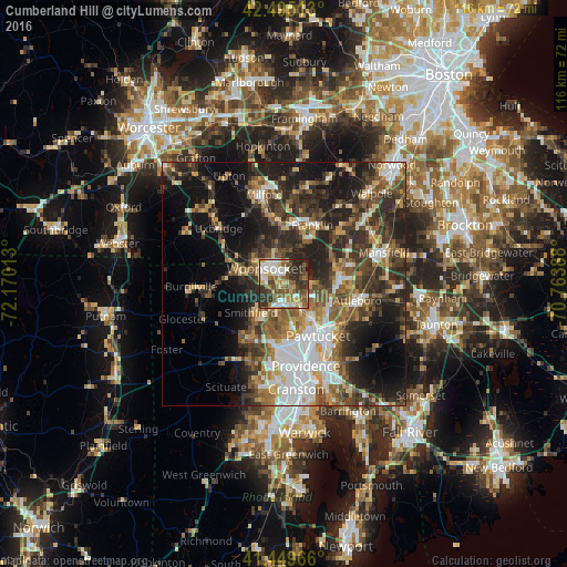
Analysis of Cumberland Hill night lights 2016
Square area 10x10 km:
 11.43%
90-99
12.06%80-89
7.62%70-79
6.51%60-69
10.48%50-59
12.22%40-49
13.65%30-39
14.6%20-29
10.95%10-19
0.48%0-9
0%Square area 50x50 km:
6.02%90-99
5.6%80-89
3.69%70-79
4.01%60-69
5.35%50-59
6.48%40-49
7.16%30-39
8.17%20-29
12.16%10-19
14.56%0-9
26.8%Clear (daylight) street map image can be seen on geolist.org.
Map coordinates:
42° 29' 42.5" North, 72° 10' 12.5" West
41° 58' 28.3" North, 71° 28' 1.2" West
41° 26' 58.8" North, 70° 45' 50" West
Some cities around Cumberland Hill sort by population:
• Woonsocket
5.1 km =3.2 mi,  308°
308°
• Smithfield
9 km =5.6 mi,  229°
229°
• Lincoln
6.5 km =4 mi,  155°
155°
• Central Falls
11.2 km =7 mi,  146°
146°
• Valley Falls
9.8 km =6.1 mi,  140°
140°
• North Smithfield
6.9 km =4.3 mi,  262°
262°
• Blackstone
7.8 km =4.8 mi, 308°
• Plainville
11.6 km =7.2 mi,  73°
73°
5221705 (p: 7,934)
Sources (retrieved 2019-11-25):
» Earth at Night: Flat Maps 2012, 2016