North Scituate night lights from space
Night Light of North Scituate (Rhode Island) from space (United States) Src. Average luminocity for 10x10km area is 22.0429% and for 50x50km: 30.8335%.
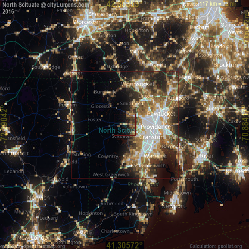
Analysis of North Scituate night lights 2016
Square area 10x10 km:
 0%
0%90-99
1.27%80-89
1.9%70-79
3.33%60-69
3.81%50-59
6.19%40-49
7.3%30-39
8.89%20-29
5.24%10-19
16.51%0-9
45.56%Square area 50x50 km:
6.25%90-99
5.32%80-89
3.19%70-79
3.98%60-69
5.04%50-59
6%40-49
4.59%30-39
4.42%20-29
7.07%10-19
8.17%0-9
45.97%Clear (daylight) street map image can be seen on geolist.org.
Map coordinates:
42° 21' 12.7" North, 72° 17' 25.5" West
41° 49' 54.4" North, 71° 35' 14.2" West
41° 18' 20.6" North, 70° 53' 3" West
Some cities around North Scituate sort by population:
• Providence
14.5 km =9 mi,  93°
93°
• Cranston
13.7 km =8.5 mi,  114°
114°
• Coventry
16.6 km =10.3 mi,  208°
208°
• West Warwick
15.9 km =9.9 mi,  160°
160°
• Johnston
6.8 km =4.2 mi,  99°
99°
• Smithfield
10.5 km =6.5 mi,  17°
17°
• Lincoln
16.1 km =10 mi,  51°
51°
• Greenville
5.3 km =3.3 mi,  33°
33°
5223685 (p: 11,171)
Sources (retrieved 2019-11-25):
» Earth at Night: Flat Maps 2012, 2016