North Miami night lights from space
Night Light of North Miami (Florida) from space (United States) Src. Average luminocity for 10x10km area is 96.1837% and for 50x50km: 59.8816%.
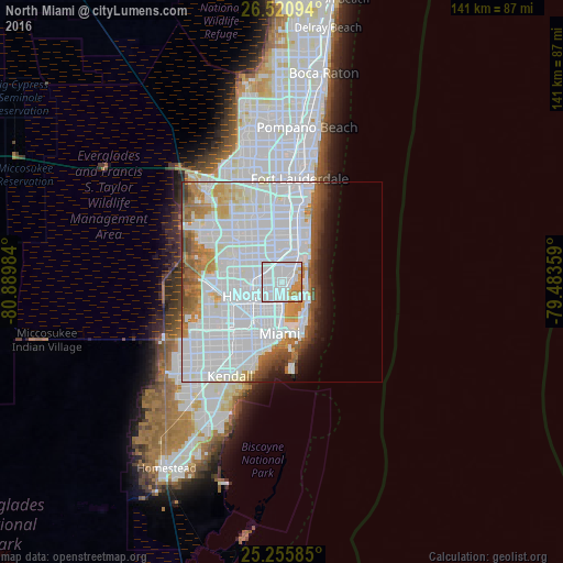


Analysis of North Miami night lights 2016
Square area 10x10 km:
 69.7%
69.7%90-99
17.05%80-89
1.7%70-79
9.66%60-69
1.89%50-59
0%40-49
0%30-39
0%20-29
0%10-19
0%0-9
0%Square area 50x50 km:
34.94%90-99
12.14%80-89
2.81%70-79
3.67%60-69
4.65%50-59
2.97%40-49
3.41%30-39
1.94%20-29
1.77%10-19
3.77%0-9
27.95%Clear (daylight) street map image can be seen on geolist.org.
Map coordinates:
26° 31' 15.4" North, 80° 53' 23.4" West
25° 53' 24.3" North, 80° 11' 12.2" West
25° 15' 21.1" North, 79° 29' 0.9" West
Some cities around North Miami sort by population:
• West Little River
6.2 km =3.9 mi,  233°
233°
• Golden Glades
2.8 km =1.7 mi,  330°
330°
• Opa-locka
6.5 km =4 mi,  282°
282°
• Pinewood
3.8 km =2.4 mi, 232°
• Miami Shores
3.1 km =1.9 mi,  191°
191°
• Westview
5.6 km =3.5 mi,  260°
260°
• Bay Harbor Islands
5.6 km =3.5 mi,  92°
92°
• Surfside
6.2 km =3.9 mi,  101°
101°
4166232 (p: 62,435)
Sources (retrieved 2019-11-25):
» NASA, Earths city lights 1995
» NASA city lights 2003
» Earth at Night: Flat Maps 2012, 2016