Newcastle night lights from space
Night Light of Newcastle (Washington) from space (United States) Src. Average luminocity for 10x10km area is 59.9616% and for 50x50km: 40.1709%.
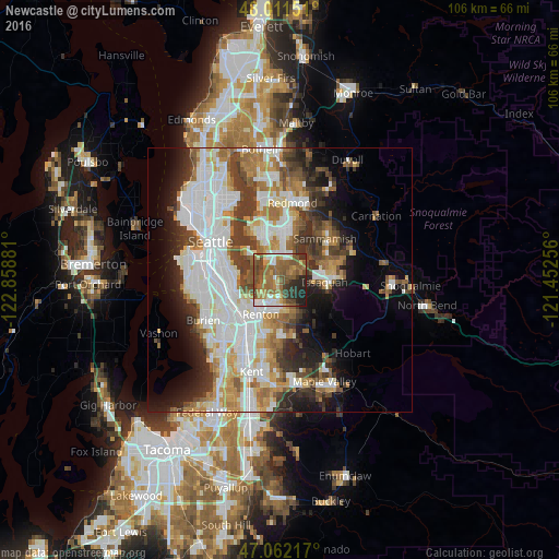
Analysis of Newcastle night lights 2016
Square area 10x10 km:
 7.81%
7.81%90-99
8.52%80-89
5.82%70-79
8.52%60-69
19.18%50-59
19.18%40-49
10.51%30-39
5.97%20-29
11.65%10-19
2.84%0-9
0%Square area 50x50 km:
11.33%90-99
9.39%80-89
3.32%70-79
4.5%60-69
5.73%50-59
4.62%40-49
4.93%30-39
5.36%20-29
6%10-19
8.17%0-9
36.66%Clear (daylight) street map image can be seen on geolist.org.
Map coordinates:
48° 0' 41.4" North, 122° 51' 31.7" West
47° 32' 20.4" North, 122° 9' 20.4" West
47° 3' 43.8" North, 121° 27' 9.2" West
Some cities around Newcastle sort by population:
• Bellevue
8.6 km =5.3 mi,  336°
336°
• Renton
7.8 km =4.8 mi,  216°
216°
• Issaquah
9.3 km =5.8 mi,  96°
96°
• West Lake Sammamish
5.9 km =3.7 mi,  43°
43°
• Mercer Island
6.1 km =3.8 mi,  305°
305°
• Fairwood
10.1 km =6.3 mi,  180°
180°
• Bryn Mawr-Skyway
8.1 km =5 mi,  232°
232°
• East Renton Highlands
6.8 km =4.2 mi,  151°
151°
5804676 (p: 11,370)
Sources (retrieved 2019-11-25):
» Earth at Night: Flat Maps 2012, 2016