Newark night lights from space
Night Light of Newark (New York) from space (United States) Src. Average luminocity for 10x10km area is 13.1651% and for 50x50km: 7.0032%.
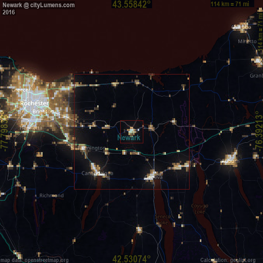
Analysis of Newark night lights 2016
Square area 10x10 km:
 1.43%
1.43%90-99
1.75%80-89
1.27%70-79
1.27%60-69
3.49%50-59
1.27%40-49
0.79%30-39
1.75%20-29
2.22%10-19
0.95%0-9
83.81%Square area 50x50 km:
0.48%90-99
0.82%80-89
0.64%70-79
0.61%60-69
0.97%50-59
1.13%40-49
1.3%30-39
1.52%20-29
1.4%10-19
5.36%0-9
85.76%Clear (daylight) street map image can be seen on geolist.org.
Map coordinates:
43° 33' 30.3" North, 77° 47' 54.2" West
43° 2' 48.2" North, 77° 5' 42.9" West
42° 31' 50.7" North, 76° 23' 31.7" West
Some cities around Newark sort by population:
• Brighton
38.6 km =24 mi,  286°
286°
• Geneva
22 km =13.7 mi,  154°
154°
• Canandaigua
24.8 km =15.4 mi,  219°
219°
• Seneca Falls
28.6 km =17.8 mi,  121°
121°
• East Rochester
32.6 km =20.3 mi,  282°
282°
• Webster
32.8 km =20.4 mi,  304°
304°
• Fairport
28.7 km =17.8 mi, 281°
• Waterloo
24.6 km =15.3 mi,  129°
129°
5128639 (p: 8,843)
Sources (retrieved 2019-11-25):
» Earth at Night: Flat Maps 2012, 2016