Geneva night lights from space
Night Light of Geneva (New York) from space (United States) Src. Average luminocity for 10x10km area is 21.646% and for 50x50km: 4.7311%.
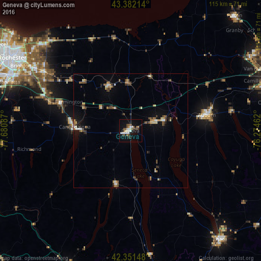
Analysis of Geneva night lights 2016
Square area 10x10 km:
 4.13%
4.13%90-99
4.29%80-89
1.11%70-79
0.79%60-69
1.9%50-59
4.6%40-49
3.02%30-39
2.54%20-29
1.75%10-19
19.21%0-9
56.67%Square area 50x50 km:
0.44%90-99
0.64%80-89
0.39%70-79
0.55%60-69
0.61%50-59
0.75%40-49
0.75%30-39
0.92%20-29
0.81%10-19
2.49%0-9
91.65%Clear (daylight) street map image can be seen on geolist.org.
Map coordinates:
43° 22' 55.7" North, 77° 40' 51.1" West
42° 52' 8.3" North, 76° 58' 39.9" West
42° 21' 5.3" North, 76° 16' 28.6" West
Some cities around Geneva sort by population:
• Auburn
34.3 km =21.3 mi,  78°
78°
• Canandaigua
25.3 km =15.7 mi,  271°
271°
• Newark
22 km =13.7 mi,  334°
334°
• Seneca Falls
15.5 km =9.6 mi,  72°
72°
• Centerport
36.7 km =22.8 mi,  58°
58°
• Fairport
45.6 km =28.3 mi,  304°
304°
• Waterloo
10.2 km =6.3 mi, 66°
• Penn Yan
24 km =14.9 mi,  195°
195°
5118398 (p: 13,062)
Sources (retrieved 2019-11-25):
» Earth at Night: Flat Maps 2012, 2016