Webster night lights from space
Night Light of Webster (New York) from space (United States) Src. Average luminocity for 10x10km area is 38.2924% and for 50x50km: 21.7161%.
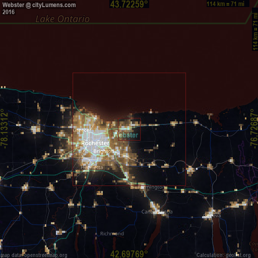
Analysis of Webster night lights 2016
Square area 10x10 km:
 3.03%
3.03%90-99
3.48%80-89
3.64%70-79
3.64%60-69
7.27%50-59
10.15%40-49
13.48%30-39
9.09%20-29
10.61%10-19
24.09%0-9
11.52%Square area 50x50 km:
4.58%90-99
3.48%80-89
2%70-79
2.33%60-69
3.48%50-59
5.32%40-49
4.1%30-39
2.24%20-29
3.66%10-19
6.96%0-9
61.86%Clear (daylight) street map image can be seen on geolist.org.
Map coordinates:
43° 43' 21.3" North, 78° 7' 59.2" West
43° 12' 44.2" North, 77° 25' 48" West
42° 41' 51.7" North, 76° 43' 36.7" West
Some cities around Webster sort by population:
• Rochester
16.3 km =10.1 mi,  246°
246°
• Irondequoit
12.1 km =7.5 mi,  270°
270°
• Brighton
12.1 km =7.5 mi,  233°
233°
• Gates-North Gates
22.6 km =14 mi,  256°
256°
• Greece
21.3 km =13.2 mi, 269°
• North Gates
22.4 km =13.9 mi, 259°
• East Rochester
12.4 km =7.7 mi,  202°
202°
• Fairport
12.7 km =7.9 mi,  184°
184°
5143495 (p: 5,534)
Sources (retrieved 2019-11-25):
» Earth at Night: Flat Maps 2012, 2016