Canandaigua night lights from space
Night Light of Canandaigua (New York) from space (United States) Src. Average luminocity for 10x10km area is 23.3159% and for 50x50km: 7.8813%.
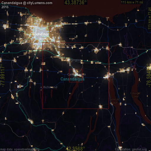
Analysis of Canandaigua night lights 2016
Square area 10x10 km:
 2.7%
2.7%90-99
6.19%80-89
2.22%70-79
2.7%60-69
1.59%50-59
1.43%40-49
2.38%30-39
4.29%20-29
5.08%10-19
22.86%0-9
48.57%Square area 50x50 km:
0.59%90-99
0.78%80-89
0.54%70-79
0.78%60-69
1.23%50-59
2.15%40-49
1.91%30-39
1.61%20-29
1.81%10-19
5.22%0-9
83.4%Clear (daylight) street map image can be seen on geolist.org.
Map coordinates:
43° 23' 14.5" North, 77° 59' 28.2" West
42° 52' 27.2" North, 77° 17' 16.9" West
42° 21' 24.5" North, 76° 35' 5.7" West
Some cities around Canandaigua sort by population:
• Brighton
37.1 km =23.1 mi,  324°
324°
• Geneva
25.3 km =15.7 mi,  91°
91°
• Newark
24.8 km =15.4 mi,  39°
39°
• East Rochester
30.7 km =19.1 mi,  328°
328°
• Webster
39.3 km =24.4 mi,  342°
342°
• Fairport
27.9 km =17.3 mi, 333°
• Waterloo
34.8 km =21.6 mi,  84°
84°
• Penn Yan
30.5 km =19 mi,  141°
141°
5111405 (p: 10,431)
Sources (retrieved 2019-11-25):
» Earth at Night: Flat Maps 2012, 2016