New Castle night lights from space
Night Light of New Castle (Indiana) from space (United States) Src. Average luminocity for 10x10km area is 33.2381% and for 50x50km: 6.3039%.
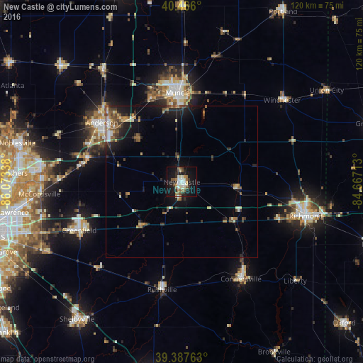
Analysis of New Castle night lights 2016
Square area 10x10 km:
 4.42%
4.42%90-99
8.5%80-89
2.55%70-79
2.55%60-69
4.42%50-59
4.76%40-49
3.57%30-39
4.76%20-29
7.65%10-19
34.18%0-9
22.62%Square area 50x50 km:
0.53%90-99
0.81%80-89
0.71%70-79
0.58%60-69
0.76%50-59
1.15%40-49
0.97%30-39
1.13%20-29
2.02%10-19
5.1%0-9
86.24%Clear (daylight) street map image can be seen on geolist.org.
Map coordinates:
40° 27' 57.6" North, 86° 4' 24.2" West
39° 55' 44.2" North, 85° 22' 12.9" West
39° 23' 15.5" North, 84° 40' 1.7" West
Some cities around New Castle sort by population:
• Muncie
29.4 km =18.3 mi,  357°
357°
• Anderson
32.9 km =20.4 mi,  306°
306°
• Richmond
42.4 km =26.3 mi,  105°
105°
• Greenfield
37.6 km =23.4 mi,  244°
244°
• Connersville
37.5 km =23.3 mi,  148°
148°
• Yorktown
29.2 km =18.1 mi,  338°
338°
• Rushville
36.1 km =22.4 mi,  190°
190°
• Alexandria
45.3 km =28.1 mi,  325°
325°
4262072 (p: 17,621)
Sources (retrieved 2019-11-25):
» Earth at Night: Flat Maps 2012, 2016