Alexandria night lights from space
Night Light of Alexandria (Indiana) from space (United States) Src. Average luminocity for 10x10km area is 13.9919% and for 50x50km: 12.4557%.
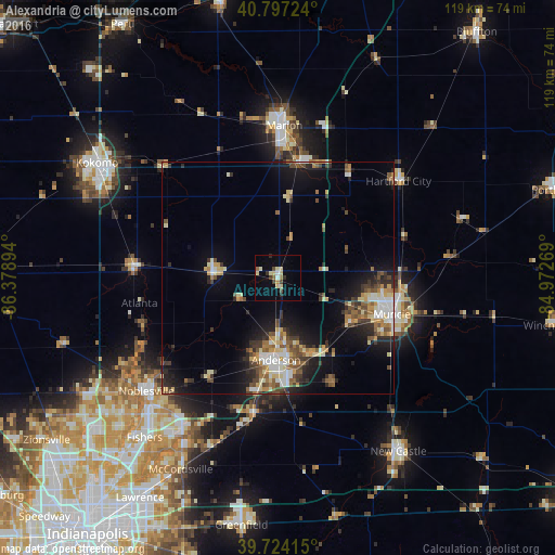
Analysis of Alexandria night lights 2016
Square area 10x10 km:
 0.81%
0.81%90-99
1.79%80-89
4.55%70-79
0.97%60-69
0.32%50-59
1.46%40-49
2.44%30-39
1.46%20-29
1.79%10-19
1.14%0-9
83.28%Square area 50x50 km:
1.45%90-99
1.86%80-89
1.9%70-79
1.33%60-69
1.41%50-59
1.9%40-49
2.17%30-39
1.93%20-29
3%10-19
7.15%0-9
75.89%Clear (daylight) street map image can be seen on geolist.org.
Map coordinates:
40° 47' 50.1" North, 86° 22' 44.2" West
40° 15' 46.2" North, 85° 40' 32.9" West
39° 43' 26.9" North, 84° 58' 21.7" West
Some cities around Alexandria sort by population:
• Muncie
25.8 km =16 mi,  107°
107°
• Anderson
17.5 km =10.9 mi,  181°
181°
• Marion
32.9 km =20.4 mi,  2°
2°
• Yorktown
18.3 km =11.4 mi,  122°
122°
• Elwood
14.2 km =8.8 mi,  276°
276°
• Hartford City
33.3 km =20.7 mi,  51°
51°
• Gas City
25.5 km =15.8 mi,  12°
12°
• Tipton
31.1 km =19.3 mi,  273°
273°
4917537 (p: 5,047)
Sources (retrieved 2019-11-25):
» Earth at Night: Flat Maps 2012, 2016