Connersville night lights from space
Night Light of Connersville (Indiana) from space (United States) Src. Average luminocity for 10x10km area is 22.3815% and for 50x50km: 4.8942%.
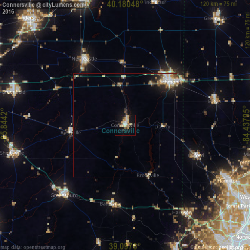
Analysis of Connersville night lights 2016
Square area 10x10 km:
 2.11%
2.11%90-99
5.03%80-89
2.92%70-79
2.92%60-69
3.25%50-59
2.6%40-49
0.97%30-39
3.08%20-29
2.44%10-19
20.29%0-9
54.38%Square area 50x50 km:
0.69%90-99
0.91%80-89
0.7%70-79
0.38%60-69
0.66%50-59
0.62%40-49
0.64%30-39
0.65%20-29
1.09%10-19
2.41%0-9
91.24%Clear (daylight) street map image can be seen on geolist.org.
Map coordinates:
40° 10' 49.7" North, 85° 50' 39.1" West
39° 38' 28.2" North, 85° 8' 27.9" West
39° 5' 51.4" North, 84° 26' 16.6" West
Some cities around Connersville sort by population:
• Richmond
29.9 km =18.6 mi,  45°
45°
• Oxford
37.1 km =23.1 mi,  113°
113°
• New Castle
37.5 km =23.3 mi,  328°
328°
• Greensburg
44.8 km =27.8 mi,  221°
221°
• Harrison
50.4 km =31.3 mi,  146°
146°
• Eaton
44.6 km =27.7 mi,  75°
75°
• Batesville
38.6 km =24 mi,  190°
190°
• Rushville
26.4 km =16.4 mi,  262°
262°
4256085 (p: 13,010)
Sources (retrieved 2019-11-25):
» Earth at Night: Flat Maps 2012, 2016