Sanibel night lights from space
Night Light of Sanibel (Florida) from space (United States) Src. Average luminocity for 10x10km area is 11.7292% and for 50x50km: 27.061%.
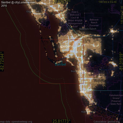
Analysis of Sanibel night lights 2016
Square area 10x10 km:
 0.19%
0.19%90-99
0.19%80-89
0%70-79
0%60-69
3.03%50-59
3.6%40-49
2.08%30-39
1.33%20-29
6.25%10-19
13.83%0-9
69.51%Square area 50x50 km:
4.76%90-99
5.6%80-89
3.26%70-79
6.21%60-69
7.91%50-59
2.25%40-49
1.38%30-39
1.57%20-29
3.63%10-19
4.94%0-9
58.49%Clear (daylight) street map image can be seen on geolist.org.
Map coordinates:
27° 4' 36.4" North, 82° 43' 31.6" West
26° 26' 56.3" North, 82° 1' 20.3" West
25° 49' 3.8" North, 81° 19' 9.1" West
Some cities around Sanibel sort by population:
• Cape Coral
14.6 km =9.1 mi,  29°
29°
• Estero
21.5 km =13.4 mi,  93°
93°
• San Carlos Park
22.1 km =13.7 mi,  84°
84°
• Iona
9.8 km =6.1 mi,  36°
36°
• Cypress Lake
15.8 km =9.8 mi,  51°
51°
• Villas
19 km =11.8 mi, 53°
• McGregor
16.4 km =10.2 mi, 40°
• Fort Myers Beach
7.2 km =4.5 mi, 86°
4172052 (p: 7,236)
Sources (retrieved 2019-11-25):
» Earth at Night: Flat Maps 2012, 2016