Mineral Wells night lights from space
Night Light of Mineral Wells (Texas) from space (United States) Src. Average luminocity for 10x10km area is 26.1084% and for 50x50km: 2.6468%.
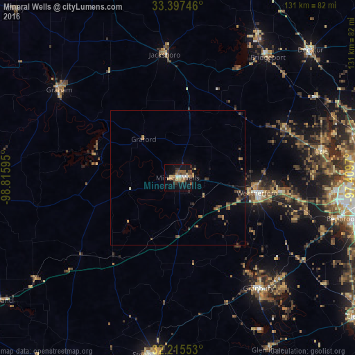
Analysis of Mineral Wells night lights 2016
Square area 10x10 km:
 2.27%
2.27%90-99
1.92%80-89
2.8%70-79
4.9%60-69
4.9%50-59
5.42%40-49
5.07%30-39
3.85%20-29
3.15%10-19
25.7%0-9
40.03%Square area 50x50 km:
0.09%90-99
0.08%80-89
0.3%70-79
0.48%60-69
0.45%50-59
0.56%40-49
0.59%30-39
0.48%20-29
0.32%10-19
1.89%0-9
94.76%Clear (daylight) street map image can be seen on geolist.org.
Map coordinates:
33° 23' 50.9" North, 98° 48' 57.4" West
32° 48' 30.5" North, 98° 6' 46.2" West
32° 12' 55.9" North, 97° 24' 34.9" West
Some cities around Mineral Wells sort by population:
• Weatherford
30 km =18.6 mi,  100°
100°
• Benbrook
62.8 km =39 mi, 103°
• White Settlement
61.4 km =38.2 mi, 95°
• Azle
53.8 km =33.4 mi,  79°
79°
• Granbury
50.5 km =31.4 mi,  143°
143°
• Graham
55.5 km =34.5 mi,  306°
306°
• Bridgeport
55.8 km =34.7 mi,  36°
36°
• Briar
57.1 km =35.5 mi,  68°
68°
4711647 (p: 14,754)
Sources (retrieved 2019-11-25):
» Earth at Night: Flat Maps 2012, 2016