Bridgeport night lights from space
Night Light of Bridgeport (Texas) from space (United States) Src. Average luminocity for 10x10km area is 20.3304% and for 50x50km: 4.8944%.
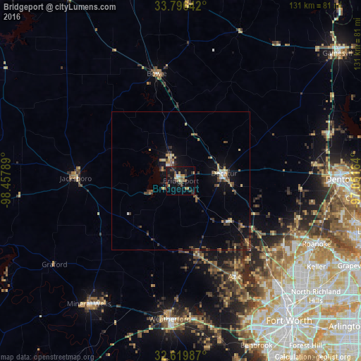
Analysis of Bridgeport night lights 2016
Square area 10x10 km:
 1.05%
1.05%90-99
1.05%80-89
1.75%70-79
3.32%60-69
3.5%50-59
4.2%40-49
2.62%30-39
5.77%20-29
4.02%10-19
23.95%0-9
48.78%Square area 50x50 km:
0.24%90-99
0.28%80-89
0.63%70-79
0.61%60-69
0.88%50-59
0.76%40-49
0.82%30-39
1.23%20-29
0.84%10-19
3.92%0-9
89.79%Clear (daylight) street map image can be seen on geolist.org.
Map coordinates:
33° 47' 47.1" North, 98° 27' 28.4" West
33° 12' 36.4" North, 97° 45' 17.1" West
32° 37' 11.5" North, 97° 3' 5.9" West
Some cities around Bridgeport sort by population:
• Weatherford
50.3 km =31.3 mi,  184°
184°
• Saginaw
53.3 km =33.1 mi,  136°
136°
• Azle
40.1 km =24.9 mi,  150°
150°
• Roanoke
54.3 km =33.7 mi,  114°
114°
• Eagle Mountain
45.6 km =28.3 mi, 140°
• Decatur
15.9 km =9.9 mi,  80°
80°
• Briar
31 km =19.3 mi, 140°
• Bowie
39.8 km =24.7 mi,  347°
347°
4676327 (p: 6,381)
Sources (retrieved 2019-11-25):
» Earth at Night: Flat Maps 2012, 2016