Granbury night lights from space
Night Light of Granbury (Texas) from space (United States) Src. Average luminocity for 10x10km area is 42.5714% and for 50x50km: 7.0055%.
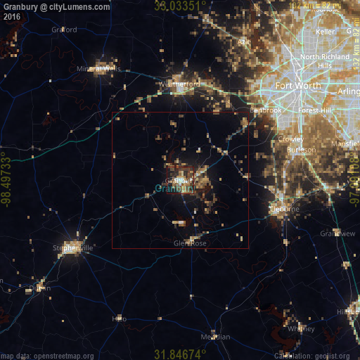
Analysis of Granbury night lights 2016
Square area 10x10 km:
 3.85%
3.85%90-99
3.48%80-89
5.49%70-79
5.68%60-69
7.88%50-59
7.33%40-49
13.55%30-39
13.37%20-29
13.55%10-19
20.7%0-9
5.13%Square area 50x50 km:
0.24%90-99
0.26%80-89
0.68%70-79
1.14%60-69
1.1%50-59
1.2%40-49
2.01%30-39
2.1%20-29
1.85%10-19
4.07%0-9
85.35%Clear (daylight) street map image can be seen on geolist.org.
Map coordinates:
33° 2' 0.6" North, 98° 29' 50.4" West
32° 26' 31.5" North, 97° 47' 39.1" West
31° 50' 48.3" North, 97° 5' 27.9" West
Some cities around Granbury sort by population:
• Cleburne
39.7 km =24.7 mi,  105°
105°
• Weatherford
35.3 km =21.9 mi,  359°
359°
• Benbrook
40.5 km =25.2 mi,  50°
50°
• Stephenville
45.6 km =28.3 mi,  237°
237°
• Crowley
43.2 km =26.8 mi,  69°
69°
• Keene
44.4 km =27.6 mi,  96°
96°
• Joshua
38.2 km =23.7 mi,  86°
86°
• Pecan Plantation
14.4 km =8.9 mi,  129°
129°
4694459 (p: 9,386)
Sources (retrieved 2019-11-25):
» Earth at Night: Flat Maps 2012, 2016