Briar night lights from space
Night Light of Briar (Texas) from space (United States) Src. Average luminocity for 10x10km area is 20.6007% and for 50x50km: 26.8275%.
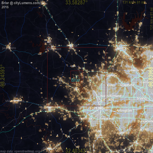
Analysis of Briar night lights 2016
Square area 10x10 km:
 0%
0%90-99
0%80-89
2.01%70-79
1.83%60-69
3.48%50-59
2.2%40-49
2.93%30-39
9.52%20-29
9.71%10-19
38.83%0-9
29.49%Square area 50x50 km:
4.29%90-99
4.02%80-89
3.82%70-79
3.41%60-69
4.2%50-59
4.47%40-49
4.6%30-39
4.89%20-29
6.58%10-19
10%0-9
49.73%Clear (daylight) street map image can be seen on geolist.org.
Map coordinates:
33° 34' 58.3" North, 98° 14' 45.3" West
32° 59' 42.4" North, 97° 32' 34.1" West
32° 24' 12.3" North, 96° 50' 22.8" West
Some cities around Briar sort by population:
• Keller
28 km =17.4 mi,  103°
103°
• Saginaw
22.5 km =14 mi,  131°
131°
• White Settlement
27.4 km =17 mi,  163°
163°
• Azle
11.1 km =6.9 mi,  181°
181°
• River Oaks
27.9 km =17.3 mi,  150°
150°
• Roanoke
29.6 km =18.4 mi,  88°
88°
• Eagle Mountain
14.6 km =9.1 mi,  140°
140°
• Decatur
26.9 km =16.7 mi,  351°
351°
4676266 (p: 5,665)
Sources (retrieved 2019-11-25):
» Earth at Night: Flat Maps 2012, 2016