Milton night lights from space
Night Light of Milton (Washington) from space (United States) Src. Average luminocity for 10x10km area is 79.4985% and for 50x50km: 40.5331%.
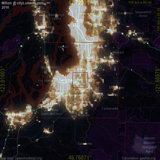
Analysis of Milton night lights 2016
Square area 10x10 km:
 17.86%
90-99
16.52%80-89
12.35%70-79
16.82%60-69
26.64%50-59
9.82%40-49
0%30-39
0%20-29
0%10-19
0%0-9
0%Square area 50x50 km:
9.69%90-99
8.51%80-89
3.57%70-79
5.32%60-69
6.77%50-59
6.66%40-49
4.43%30-39
4.59%20-29
7.16%10-19
10.6%0-9
32.7%Clear (daylight) street map image can be seen on geolist.org.
Map coordinates:
47° 43' 23.9" North, 123° 0' 57.7" West
47° 14' 53.4" North, 122° 18' 46.4" West
46° 46' 7.4" North, 121° 36' 35.2" West
Some cities around Milton sort by population:
• Federal Way
8.2 km =5.1 mi,  0°
0°
• Puyallup
7.1 km =4.4 mi,  167°
167°
• Lakeland South
4 km =2.5 mi,  33°
33°
• Fife
3.5 km =2.2 mi,  253°
253°
• Edgewood
1.5 km =0.9 mi,  81°
81°
• Sumner
7.4 km =4.6 mi,  132°
132°
• Waller
6.8 km =4.2 mi,  218°
218°
• Pacific
5.1 km =3.2 mi,  68°
68°
5803556 (p: 7,670)
Sources (retrieved 2019-11-25):
» Earth at Night: Flat Maps 2012, 2016