Fife night lights from space
Night Light of Fife (Washington) from space (United States) Src. Average luminocity for 10x10km area is 84.3467% and for 50x50km: 39.3398%.
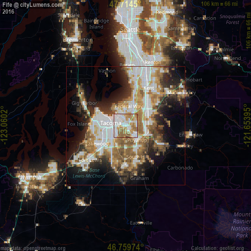
Analysis of Fife night lights 2016
Square area 10x10 km:
 29.17%
90-99
23.21%80-89
7.59%70-79
14.29%60-69
14.88%50-59
9.97%40-49
0.89%30-39
0%20-29
0%10-19
0%0-9
0%Square area 50x50 km:
9.3%90-99
8.17%80-89
3.5%70-79
5.23%60-69
6.57%50-59
6.56%40-49
4.33%30-39
4.37%20-29
7.13%10-19
10.5%0-9
34.34%Clear (daylight) street map image can be seen on geolist.org.
Map coordinates:
47° 42' 52.2" North, 123° 3' 36.7" West
47° 14' 21.4" North, 122° 21' 25.5" West
46° 45' 35.1" North, 121° 39' 14.2" West
Some cities around Fife sort by population:
• Tacoma
6.8 km =4.2 mi,  282°
282°
• Puyallup
7.7 km =4.8 mi,  141°
141°
• Lakeland South
7.1 km =4.4 mi,  51°
51°
• Edgewood
4.9 km =3 mi,  75°
75°
• Summit
8.6 km =5.3 mi,  180°
180°
• Waller
4.4 km =2.7 mi,  192°
192°
• Milton
3.5 km =2.2 mi,  73°
73°
• Pacific
8.5 km =5.3 mi, 70°
5794328 (p: 9,970)
Sources (retrieved 2019-11-25):
» Earth at Night: Flat Maps 2012, 2016