Lakeland South night lights from space
Night Light of Lakeland South (Washington) from space (United States) Src. Average luminocity for 10x10km area is 84.4211% and for 50x50km: 41.9593%.
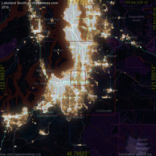
Analysis of Lakeland South night lights 2016
Square area 10x10 km:
 23.07%
90-99
23.07%80-89
12.5%70-79
18.01%60-69
20.68%50-59
2.68%40-49
0%30-39
0%20-29
0%10-19
0%0-9
0%Square area 50x50 km:
10.57%90-99
9.15%80-89
3.74%70-79
5.36%60-69
6.89%50-59
6.74%40-49
4.42%30-39
4.36%20-29
6.91%10-19
9.46%0-9
32.41%Clear (daylight) street map image can be seen on geolist.org.
Map coordinates:
47° 45' 11.9" North, 122° 59' 11" West
47° 16' 42.3" North, 122° 16' 59.7" West
46° 47' 57.3" North, 121° 34' 48.5" West
Some cities around Lakeland South sort by population:
• Federal Way
5.4 km =3.4 mi,  335°
335°
• Auburn
5.2 km =3.2 mi,  52°
52°
• Lea Hill
9.3 km =5.8 mi,  55°
55°
• Fife
7.1 km =4.4 mi,  231°
231°
• Edgewood
3.2 km =2 mi,  194°
194°
• Sumner
9 km =5.6 mi,  158°
158°
• Milton
4 km =2.5 mi,  213°
213°
• Pacific
2.9 km =1.8 mi,  121°
121°
7261609 (p: 11,574)
Sources (retrieved 2019-11-25):
» Earth at Night: Flat Maps 2012, 2016