Mexico night lights from space
Night Light of Mexico (Missouri) from space (United States) Src. Average luminocity for 10x10km area is 26.586% and for 50x50km: 2.1864%.
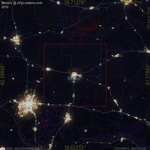
Analysis of Mexico night lights 2016
Square area 10x10 km:
 2.92%
2.92%90-99
2.6%80-89
3.73%70-79
5.36%60-69
6.66%50-59
2.76%40-49
1.62%30-39
0.97%20-29
2.11%10-19
33.6%0-9
37.66%Square area 50x50 km:
0.21%90-99
0.23%80-89
0.26%70-79
0.35%60-69
0.4%50-59
0.28%40-49
0.26%30-39
0.35%20-29
0.23%10-19
1.57%0-9
95.86%Clear (daylight) street map image can be seen on geolist.org.
Map coordinates:
39° 42' 45.9" North, 92° 35' 9.9" West
39° 10' 11.1" North, 91° 52' 58.6" West
38° 37' 21.1" North, 91° 10' 47.4" West
Some cities around Mexico sort by population:
• Columbia
45.9 km =28.5 mi,  238°
238°
• Jefferson City
70.6 km =43.9 mi,  200°
200°
• Hannibal
74.9 km =46.5 mi,  36°
36°
• Moberly
55.2 km =34.3 mi,  300°
300°
• Fulton
36.4 km =22.6 mi,  188°
188°
• Boonville
77.4 km =48.1 mi,  253°
253°
• Warrenton
75.5 km =46.9 mi,  121°
121°
• Bowling Green
62.2 km =38.6 mi,  72°
72°
4398103 (p: 11,660)
Sources (retrieved 2019-11-25):
» Earth at Night: Flat Maps 2012, 2016