Mendota night lights from space
Night Light of Mendota (Illinois) from space (United States) Src. Average luminocity for 10x10km area is 15.8997% and for 50x50km: 6.1876%.
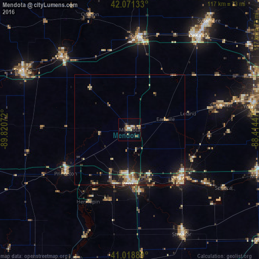
Analysis of Mendota night lights 2016
Square area 10x10 km:
 0.85%
0.85%90-99
1.87%80-89
1.53%70-79
2.21%60-69
4.76%50-59
2.89%40-49
2.72%30-39
0.17%20-29
2.55%10-19
3.4%0-9
77.04%Square area 50x50 km:
0.6%90-99
0.57%80-89
1.28%70-79
0.85%60-69
0.88%50-59
0.73%40-49
1.11%30-39
0.88%20-29
1.7%10-19
3.48%0-9
87.91%Clear (daylight) street map image can be seen on geolist.org.
Map coordinates:
42° 4' 16.8" North, 89° 49' 14.6" West
41° 32' 50.1" North, 89° 7' 3.3" West
41° 1' 8" North, 88° 24' 52.1" West
Some cities around Mendota sort by population:
• Ottawa
32.1 km =19.9 mi,  134°
134°
• Dixon
44.2 km =27.5 mi,  317°
317°
• Peru
24.4 km =15.2 mi,  182°
182°
• La Salle
23.9 km =14.9 mi,  174°
174°
• Rochelle
42.1 km =26.2 mi,  5°
5°
• Princeton
35.1 km =21.8 mi,  235°
235°
• Sandwich
42.7 km =26.5 mi,  75°
75°
• Spring Valley
25.4 km =15.8 mi,  195°
195°
4901944 (p: 7,204)
Sources (retrieved 2019-11-25):
» Earth at Night: Flat Maps 2012, 2016