Spring Valley night lights from space
Night Light of Spring Valley (Illinois) from space (United States) Src. Average luminocity for 10x10km area is 25.6122% and for 50x50km: 6.8894%.
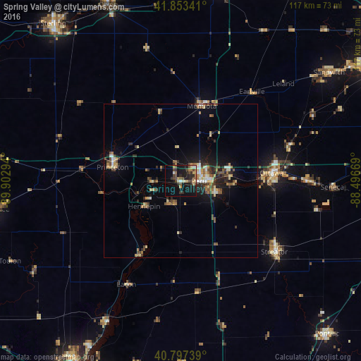
Analysis of Spring Valley night lights 2016
Square area 10x10 km:
 1.19%
1.19%90-99
1.7%80-89
3.91%70-79
3.4%60-69
3.06%50-59
3.91%40-49
7.65%30-39
3.74%20-29
7.14%10-19
30.27%0-9
34.01%Square area 50x50 km:
0.53%90-99
0.53%80-89
1.2%70-79
0.77%60-69
0.96%50-59
1.01%40-49
1.37%30-39
1.06%20-29
1.89%10-19
4.49%0-9
86.19%Clear (daylight) street map image can be seen on geolist.org.
Map coordinates:
41° 51' 12.3" North, 89° 54' 10.6" West
41° 19' 39.1" North, 89° 11' 59.3" West
40° 47' 50.6" North, 88° 29' 48.1" West
Some cities around Spring Valley sort by population:
• Ottawa
29.9 km =18.6 mi,  86°
86°
• Streator
38.2 km =23.7 mi,  127°
127°
• Peru
5.9 km =3.7 mi, 90°
• La Salle
9 km =5.6 mi, 85°
• Princeton
22.6 km =14 mi,  281°
281°
• Sandwich
59.8 km =37.2 mi,  53°
53°
• Mendota
25.4 km =15.8 mi,  15°
15°
• Chillicothe
51 km =31.7 mi,  208°
208°
4912303 (p: 5,314)
Sources (retrieved 2019-11-25):
» Earth at Night: Flat Maps 2012, 2016