Kaukauna night lights from space
Night Light of Kaukauna (Wisconsin) from space (United States) Src. Average luminocity for 10x10km area is 49.697% and for 50x50km: 19.3837%.
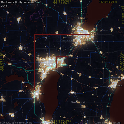
Analysis of Kaukauna night lights 2016
Square area 10x10 km:
 7.88%
7.88%90-99
10.15%80-89
7.88%70-79
6.52%60-69
8.03%50-59
9.09%40-49
5.3%30-39
4.85%20-29
13.33%10-19
19.24%0-9
7.73%Square area 50x50 km:
3.41%90-99
3.85%80-89
2.46%70-79
2.64%60-69
2.73%50-59
2.71%40-49
1.81%30-39
2.19%20-29
5.13%10-19
8.78%0-9
64.28%Clear (daylight) street map image can be seen on geolist.org.
Map coordinates:
44° 46' 45.4" North, 88° 58' 30.6" West
44° 16' 40.9" North, 88° 16' 19.4" West
43° 46' 20.9" North, 87° 34' 8.1" West
Some cities around Kaukauna sort by population:
• Appleton
11.6 km =7.2 mi,  261°
261°
• Neenah
18.3 km =11.4 mi,  235°
235°
• De Pere
25.4 km =15.8 mi,  41°
41°
• Menasha
16.3 km =10.1 mi, 238°
• Little Chute
3.7 km =2.3 mi,  273°
273°
• Hobart
26.4 km =16.4 mi,  21°
21°
• Harrison
7.6 km =4.7 mi,  222°
222°
• Kimberly
5.4 km =3.4 mi, 263°
5258296 (p: 15,854)
Sources (retrieved 2019-11-25):
» Earth at Night: Flat Maps 2012, 2016