Springfield night lights from space
Night Light of Springfield (Pennsylvania) from space (United States) Src. Average luminocity for 10x10km area is 90.9881% and for 50x50km: 75.8528%.
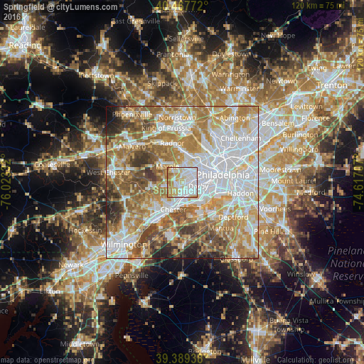
Analysis of Springfield night lights 2016
Square area 10x10 km:
 39.46%
90-99
24.83%80-89
14.97%70-79
12.76%60-69
7.99%50-59
0%40-49
0%30-39
0%20-29
0%10-19
0%0-9
0%Square area 50x50 km:
23.39%90-99
16.41%80-89
9.9%70-79
12.34%60-69
13.29%50-59
9.5%40-49
6.15%30-39
4.4%20-29
2.88%10-19
1.62%0-9
0.12%Clear (daylight) street map image can be seen on geolist.org.
Map coordinates:
40° 28' 3.8" North, 76° 1' 24" West
39° 55' 50.4" North, 75° 19' 12.7" West
39° 23' 21.8" North, 74° 37' 1.5" West
Some cities around Springfield sort by population:
• Drexel Hill
3 km =1.9 mi,  52°
52°
• Lansdowne
4.2 km =2.6 mi,  78°
78°
• Collingdale
4.2 km =2.6 mi,  119°
119°
• Folsom
4.6 km =2.9 mi,  185°
185°
• Glenolden
4.3 km =2.7 mi,  142°
142°
• Clifton Heights
2 km =1.2 mi,  94°
94°
• Swarthmore
4.1 km =2.5 mi,  218°
218°
• Norwood
4.7 km =2.9 mi,  157°
157°
4561407 (p: 23,363)
Sources (retrieved 2019-11-25):
» Earth at Night: Flat Maps 2012, 2016