Mebane night lights from space
Night Light of Mebane (North Carolina) from space (United States) Src. Average luminocity for 10x10km area is 51.2509% and for 50x50km: 18.1026%.
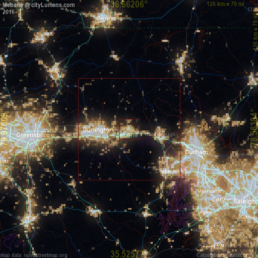
Analysis of Mebane night lights 2016
Square area 10x10 km:
 5.13%
5.13%90-99
3.48%80-89
17.4%70-79
10.44%60-69
9.34%50-59
4.4%40-49
4.76%30-39
9.34%20-29
15.93%10-19
18.5%0-9
1.28%Square area 50x50 km:
2.02%90-99
2.34%80-89
2.98%70-79
2.33%60-69
3.44%50-59
2.16%40-49
2.88%30-39
3.96%20-29
5.44%10-19
10.58%0-9
61.86%Clear (daylight) street map image can be seen on geolist.org.
Map coordinates:
36° 39' 43.4" North, 79° 58' 12.3" West
36° 5' 45.5" North, 79° 16' 1.1" West
35° 31' 32.8" North, 78° 33' 49.8" West
Some cities around Mebane sort by population:
• Durham
35 km =21.7 mi,  108°
108°
• Chapel Hill
27.8 km =17.3 mi,  136°
136°
• Burlington
15.3 km =9.5 mi,  269°
269°
• Carrboro
26.9 km =16.7 mi, 140°
• Graham
12.4 km =7.7 mi,  255°
255°
• Elon
21.6 km =13.4 mi, 272°
• Gibsonville
24.8 km =15.4 mi, 272°
• Hillsborough
15.2 km =9.4 mi,  98°
98°
4478877 (p: 13,698)
Sources (retrieved 2019-11-25):
» Earth at Night: Flat Maps 2012, 2016