McMinnville night lights from space
Night Light of McMinnville (Tennessee) from space (United States) Src. Average luminocity for 10x10km area is 39.9598% and for 50x50km: 3.328%.
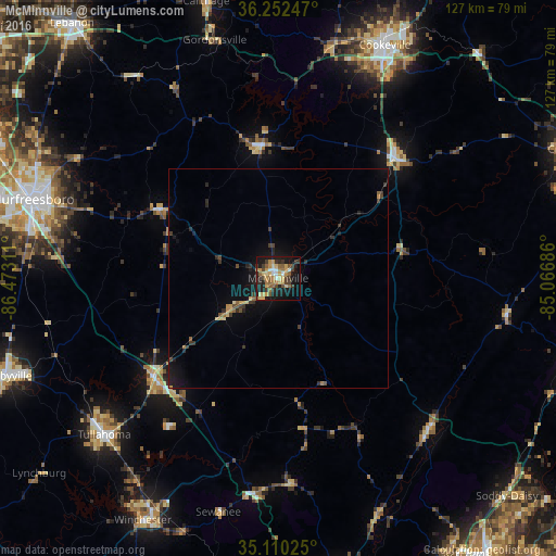
Analysis of McMinnville night lights 2016
Square area 10x10 km:
 3.67%
3.67%90-99
2.27%80-89
9.97%70-79
7.69%60-69
6.64%50-59
6.47%40-49
5.77%30-39
9.09%20-29
5.07%10-19
32.87%0-9
10.49%Square area 50x50 km:
0.15%90-99
0.09%80-89
0.59%70-79
0.5%60-69
0.41%50-59
0.46%40-49
0.46%30-39
1.02%20-29
0.68%10-19
3.16%0-9
92.46%Clear (daylight) street map image can be seen on geolist.org.
Map coordinates:
36° 15' 8.9" North, 86° 28' 23.2" West
35° 41' 0.2" North, 85° 46' 11.9" West
35° 6' 36.9" North, 85° 4' 0.7" West
Some cities around McMinnville sort by population:
• Murfreesboro
58.8 km =36.5 mi,  287°
287°
• Cookeville
58.5 km =36.4 mi,  24°
24°
• Tullahoma
53.5 km =33.2 mi,  228°
228°
• Manchester
36.5 km =22.7 mi, 232°
• Christiana
56.9 km =35.4 mi,  272°
272°
• Winchester
63.4 km =39.4 mi,  209°
209°
• Dunlap
48.8 km =30.3 mi,  135°
135°
• Sparta
38.6 km =24 mi,  45°
45°
4640882 (p: 13,759)
Sources (retrieved 2019-11-25):
» Earth at Night: Flat Maps 2012, 2016