Sparta night lights from space
Night Light of Sparta (Tennessee) from space (United States) Src. Average luminocity for 10x10km area is 27.0458% and for 50x50km: 5.0825%.
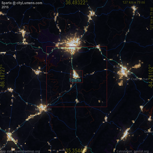
Analysis of Sparta night lights 2016
Square area 10x10 km:
 3.66%
3.66%90-99
4.58%80-89
4.95%70-79
4.03%60-69
2.38%50-59
4.58%40-49
2.56%30-39
0.37%20-29
2.75%10-19
29.67%0-9
40.48%Square area 50x50 km:
0.43%90-99
0.52%80-89
0.75%70-79
0.7%60-69
0.56%50-59
0.89%40-49
0.6%30-39
1.56%20-29
1.24%10-19
3.56%0-9
89.19%Clear (daylight) street map image can be seen on geolist.org.
Map coordinates:
36° 29' 35.6" North, 86° 10' 2.2" West
35° 55' 33.2" North, 85° 27' 50.9" West
35° 21' 16.1" North, 84° 45' 39.7" West
Some cities around Sparta sort by population:
• Cookeville
26.6 km =16.5 mi,  352°
352°
• McMinnville
38.6 km =24 mi,  225°
225°
• Crossville
39.4 km =24.5 mi,  86°
86°
• Manchester
75 km =46.6 mi, 228°
• Dayton
63 km =39.1 mi,  139°
139°
• Fairfield Glade
52.7 km =32.7 mi,  80°
80°
• Rockwood
70.5 km =43.8 mi,  95°
95°
• Dunlap
62 km =38.5 mi,  173°
173°
4659177 (p: 5,096)
Sources (retrieved 2019-11-25):
» Earth at Night: Flat Maps 2012, 2016