Marengo night lights from space
Night Light of Marengo (Illinois) from space (United States) Src. Average luminocity for 10x10km area is 12.3015% and for 50x50km: 17.0426%.
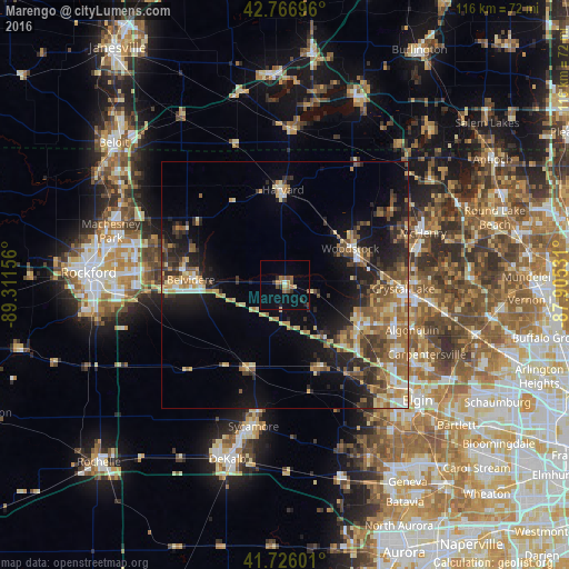
Analysis of Marengo night lights 2016
Square area 10x10 km:
 0.61%
0.61%90-99
0%80-89
1.06%70-79
1.82%60-69
2.73%50-59
3.48%40-49
1.52%30-39
1.06%20-29
2.88%10-19
3.03%0-9
81.82%Square area 50x50 km:
1.19%90-99
1.6%80-89
2.99%70-79
2.58%60-69
3.13%50-59
3.56%40-49
2.44%30-39
2.82%20-29
5%10-19
9.16%0-9
65.51%Clear (daylight) street map image can be seen on geolist.org.
Map coordinates:
42° 46' 1.1" North, 89° 18' 41.6" West
42° 14' 55.1" North, 88° 36' 30.3" West
41° 43' 33.6" North, 87° 54' 19.1" West
Some cities around Marengo sort by population:
• Crystal Lake
24.1 km =15 mi,  91°
91°
• Huntley
17.3 km =10.7 mi,  121°
121°
• Woodstock
15.1 km =9.4 mi,  60°
60°
• Belvidere
19.5 km =12.1 mi,  275°
275°
• Harvard
19.3 km =12 mi,  358°
358°
• Hampshire
18 km =11.2 mi,  159°
159°
• Genoa
18.2 km =11.3 mi,  202°
202°
• Poplar Grove
22 km =13.7 mi,  307°
307°
4901164 (p: 7,503)
Sources (retrieved 2019-11-25):
» Earth at Night: Flat Maps 2012, 2016