Genoa night lights from space
Night Light of Genoa (Illinois) from space (United States) Src. Average luminocity for 10x10km area is 8.2545% and for 50x50km: 16.9693%.
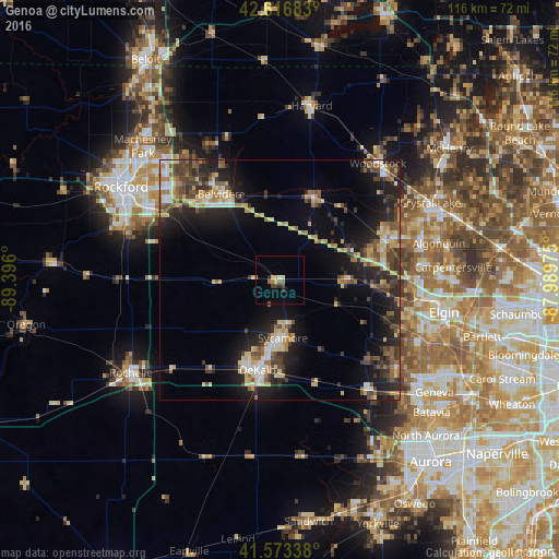
Analysis of Genoa night lights 2016
Square area 10x10 km:
 0%
0%90-99
0.61%80-89
1.82%70-79
1.67%60-69
1.21%50-59
0.76%40-49
1.21%30-39
0.91%20-29
1.82%10-19
0%0-9
90%Square area 50x50 km:
1.41%90-99
1.69%80-89
3.1%70-79
2.35%60-69
2.19%50-59
2.49%40-49
3.02%30-39
2.97%20-29
6.23%10-19
11.03%0-9
63.51%Clear (daylight) street map image can be seen on geolist.org.
Map coordinates:
42° 37' 0.6" North, 89° 23' 45.6" West
42° 5' 50.1" North, 88° 41' 34.3" West
41° 34' 24.2" North, 87° 59' 23.1" West
Some cities around Genoa sort by population:
• DeKalb
19.3 km =12 mi,  194°
194°
• Huntley
23.2 km =14.4 mi,  70°
70°
• Belvidere
22.3 km =13.9 mi,  326°
326°
• Sycamore
12.1 km =7.5 mi,  177°
177°
• Gilberts
26.4 km =16.4 mi,  88°
88°
• Marengo
18.2 km =11.3 mi,  22°
22°
• Pingree Grove
23.3 km =14.5 mi,  97°
97°
• Hampshire
13.4 km =8.3 mi, 89°
4893601 (p: 5,196)
Sources (retrieved 2019-11-25):
» Earth at Night: Flat Maps 2012, 2016