Normandy Park night lights from space
Night Light of Normandy Park (Washington) from space (United States) Src. Average luminocity for 10x10km area is 56.9432% and for 50x50km: 44.8948%.
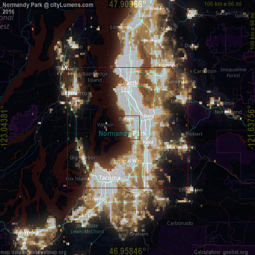
Analysis of Normandy Park night lights 2016
Square area 10x10 km:
 18.18%
90-99
16.62%80-89
8.52%70-79
3.41%60-69
5.4%50-59
3.13%40-49
2.27%30-39
4.4%20-29
10.65%10-19
13.35%0-9
14.06%Square area 50x50 km:
13.19%90-99
10.16%80-89
3.98%70-79
5.09%60-69
6.04%50-59
4.94%40-49
5.09%30-39
5.68%20-29
7.56%10-19
9.66%0-9
28.61%Clear (daylight) street map image can be seen on geolist.org.
Map coordinates:
47° 54' 34.8" North, 123° 2' 37.7" West
47° 26' 10.4" North, 122° 20' 26.4" West
46° 57' 30.5" North, 121° 38' 15.2" West
Some cities around Normandy Park sort by population:
• Burien
3.8 km =2.4 mi,  353°
353°
• Des Moines
4 km =2.5 mi,  162°
162°
• SeaTac
3.9 km =2.4 mi,  69°
69°
• Tukwila
7.3 km =4.5 mi,  54°
54°
• White Center
9.1 km =5.7 mi, 353°
• Vashon
9 km =5.6 mi,  277°
277°
• Riverton
6.4 km =4 mi,  32°
32°
• Boulevard Park
6.2 km =3.9 mi,  18°
18°
5804885 (p: 6,668)
Sources (retrieved 2019-11-25):
» Earth at Night: Flat Maps 2012, 2016