Manvel night lights from space
Night Light of Manvel (Texas) from space (United States) Src. Average luminocity for 10x10km area is 40.5265% and for 50x50km: 49.3209%.
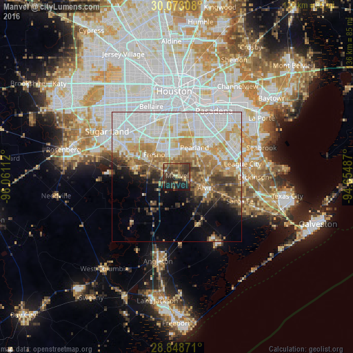
Analysis of Manvel night lights 2016
Square area 10x10 km:
 0%
0%90-99
0.95%80-89
7.58%70-79
3.03%60-69
6.06%50-59
10.04%40-49
20.27%30-39
18.75%20-29
14.96%10-19
17.8%0-9
0.57%Square area 50x50 km:
15.35%90-99
11.9%80-89
6.37%70-79
6.7%60-69
5.79%50-59
4.68%40-49
4.05%30-39
4.68%20-29
3.2%10-19
5.6%0-9
31.66%Clear (daylight) street map image can be seen on geolist.org.
Map coordinates:
30° 4' 23.1" North, 96° 3' 40" West
29° 27' 45.9" North, 95° 21' 28.8" West
28° 50' 55.4" North, 94° 39' 17.5" West
Some cities around Manvel sort by population:
• Pearland
13.2 km =8.2 mi,  31°
31°
• Missouri City
24.5 km =15.2 mi,  314°
314°
• Friendswood
16.9 km =10.5 mi,  63°
63°
• Alvin
11.8 km =7.3 mi,  111°
111°
• Fresno
12.1 km =7.5 mi, 314°
• South Houston
25.2 km =15.7 mi, 28°
• Sienna Plantation
14.8 km =9.2 mi,  280°
280°
• Webster
24.7 km =15.3 mi,  70°
70°
4709027 (p: 7,950)
Sources (retrieved 2019-11-25):
» Earth at Night: Flat Maps 2012, 2016